Rummaging through the donation inventory one morning, we came across some beautiful suburban map plans, generously donated by a Pat, no surname provided. After we checked the catalogue to ensure the maps weren’t not already in the collection, we promptly accepted the donation and eagerly anticipated the opportunity to see these items in person. 

During the 1970s Pat was a member of the ladies auxiliary committee for the Campbelltown Hockey Club, where a fundraising ball was held. A band played, supper was provided, and prizes were raffled off in a lucky dip. Ever the thoughtful personality, Pat wanted those who didn’t win a prize to have the chance to take something home as a consolation prize. 

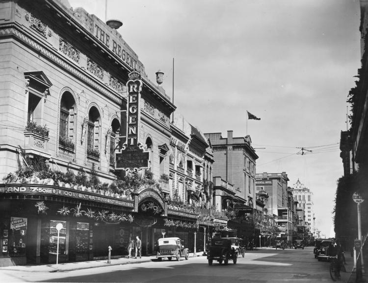
The manager of the Regent Theatre and Mr Matters of the real estate firm were duly solicited for unwanted posters. The movie posters proved particularly popular with ball goers, but luckily for us some early housing estate maps remained. They were unearthed earlier this year after two house moves, and Pat wondered if the State Library would like to add them to our collection. We sure did! 

Regent Theatre, Rundle Street Adelaide, 1937. SLSA: B 60354/67
Regent Theatre, Rundle Street, Adelaide in 1837. SLSA: B 60354/67  


In the Preservation Studio 

Once the maps were received by the State Library, our inimitable Senior Conservationist Peter Zajicek wove his magic, repairing tears and putting backing on them.  

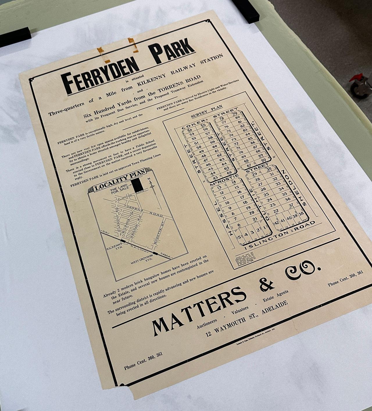
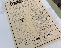
A cadastral map showing part of Ferryden Park, South Australia, 1920. SLSA zgmp 830.9 bjc-c Ferryden Park

A cadastral map showing part of Ferryden Park, South Australia, bounded by Cocker, Sheldon and Hassel Streets and Regency Road. The plan includes allotment numbers and dimensions in feet and roads. The locality plan shows where land is situated in relation to railway line, Torrens Road and Regency Road (then known as Islington Road). Includes description of the area and its amenities. SLSA: zgmp 830.9 bjc-c Ferryden Park 1920s 

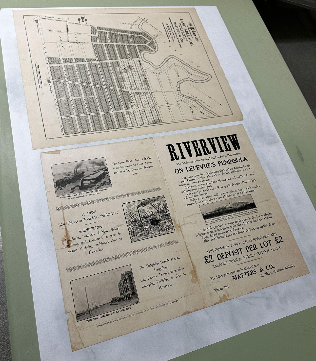
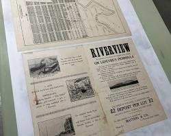
A cadastral map of land subdivision 'Riverview' on the Lefevre Peninsula, 1919. SLSA: zgmp 830.9 bjc-b Taperoo 1919

A cadastral map of land subdivision 'Riverview' on the Lefevre Peninsula near Fort Glanville, now known as Taperoo. It includes allotment and section numbers allotment dimensions in feet, roads and railway line. It also includes locality diagram, showing location of Riverview in relation to Port River, coastline, Largs jetty and surrounds. Verso includes advertising information and images of shipbuilding yards, ships at Outer Harbour and the Esplanade at Largs Bay. SLSA: zgmp 830.9 bjc-b Taperoo 1919 

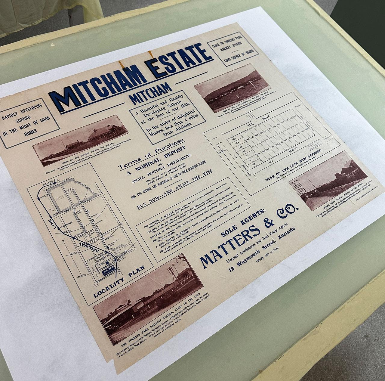
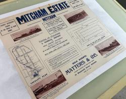
Mitcham Estate Sales Plan, 1920s. SLSA: zgmp 830.9 bjc-c Lower Mitcham 1920s

Mitcham Estate Sales Plan for land bounded by Mitcham Avenue, Rothesay Avenue (now Catherine Street), The Grove, and Hay Street, Mitcham (now part of Lower Mitcham), South Australia. 

The plan includes allotment numbers and dimensions in feet and roads. The locality plan shows the City of Adelaide, railway line, main roads and surrounding suburbs. Includes views of nearby houses, the hills and Torrens Park Railway Station. Published in the 1920s by Matters and Co. SLSA: zgmp 830.9 bjc-c Lower Mitcham 1920s 

A cadastral map showing part of Ferryden Park, South Australia, 1920. SLSA zgmp 830.9 bjc-c Ferryden Park
A cadastral map of land subdivision 'Riverview' on the Lefevre Peninsula, 1919. SLSA: zgmp 830.9 bjc-b Taperoo 1919
Mitcham Estate Sales Plan, 1920s. SLSA: zgmp 830.9 bjc-c Lower Mitcham 1920s

Researching the maps

The next step was to research when they were made, and that’s where our intrepid Librarians come back into the picture. Along with our determined research volunteer Natacha Tracey, we used a myriad of clues and sources to narrow these down. It was then over to our outstanding Senior Cataloguer Brenna Cook who went to work describing the maps and officially adding them to the collection.  

The donation of century-old maps to a library is not merely an act of generosity; it is a gesture that opens a window into history, offering a tangible connection to the past that resonates through generations. These aren’t just any maps, mind you. These treasures date back over 100 years, each one a piece of parchment whispering tales of times gone by. With this donation, we can see the formation and expansion of early suburbs in the Adelaide area. These maps are more than dusty relics. They’re a bridge between past and present, a reminder that our history isn’t just something to study - it’s something to cherish, to learn from, and to pass down to future generations. 
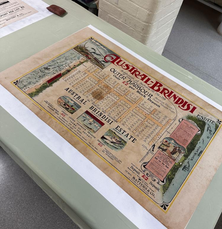
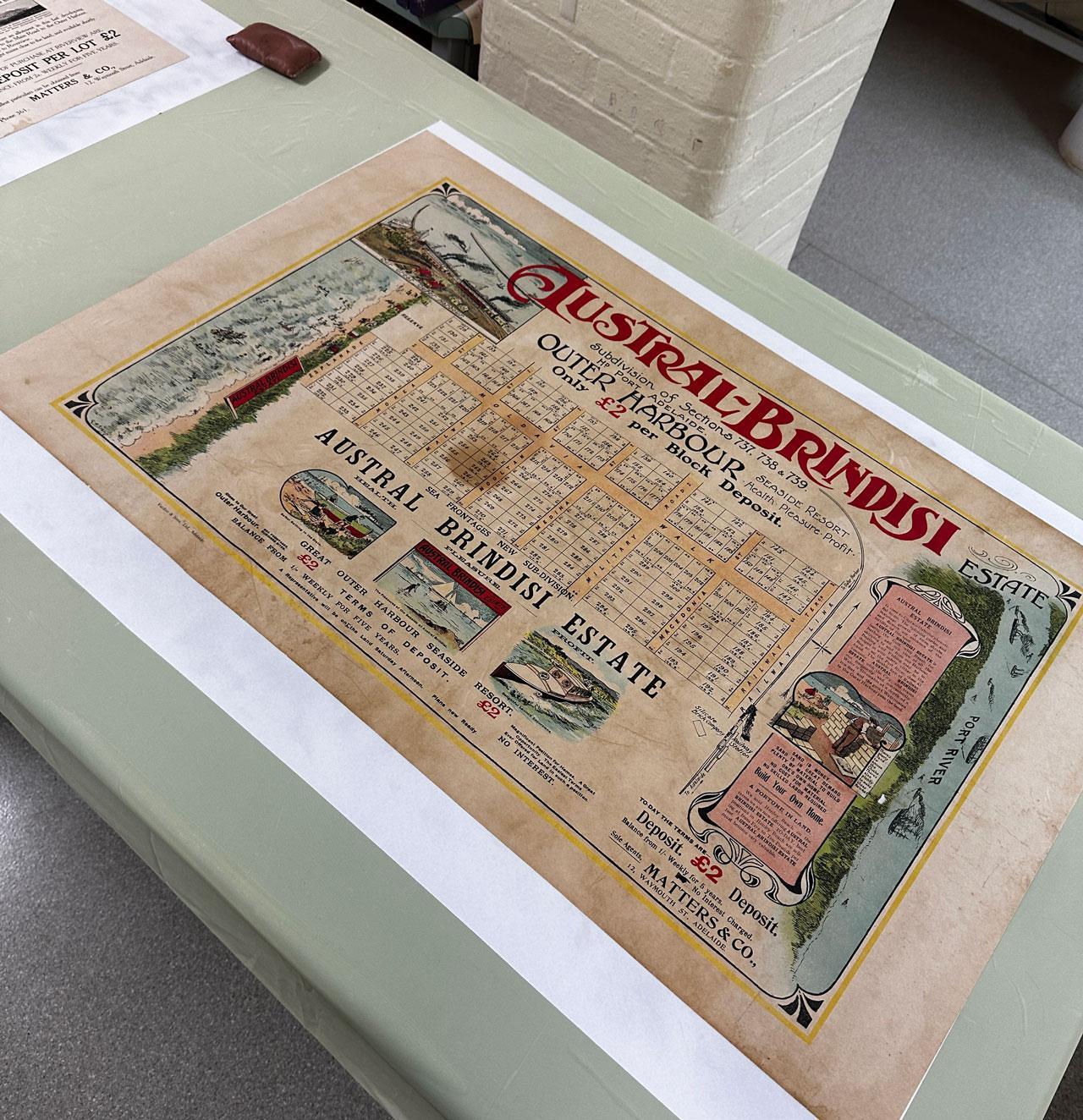
The Austral-Brindisi estate, Outer Harbour, 1911. SLSA: zgmp 830.9 bjc-c North Haven 1911
The Austral-Brindisi estate shown in this cadastral map, on the Lefevre Peninsula towards Outer Harbour, now known as North Haven. It includes allotment and section numbers, allotment dimensions in feet, roads and railway line. Around the map are colour illustrations of 'Our great Outer Harbour', the sea front, Port River and other scenes. Panel of information about the estate is decorated with Art Nouveau flourishes and shows a man in hat and waistcoat constructing a brick wall while his children play on the beach beyond. SLSA: zgmp 830.9 bjc-c North Haven 1911 

Detailing estates that are now part of established suburbs, these maps sparkle with extra information telling a story of the time. A story of exploration, colonization, and technological advancement, these documents encapsulate the aspirations and achievements of their era. A time machine, showing us how our world has evolved and grown, one ink stroke at a time; these maps are a goldmine for historians and scholars alike. They’re like puzzle pieces in a grand tapestry of human history, helping us piece together the stories of how neighbourhoods sprouted up. Suburbs we all know – Bridgewater, Ferryden Park, and Mitcham (these maps are all from the mid-1920s), and some that we may not know by these names – East Adelaide, River View, and Austral Brindisi (all from the early 1910s).  
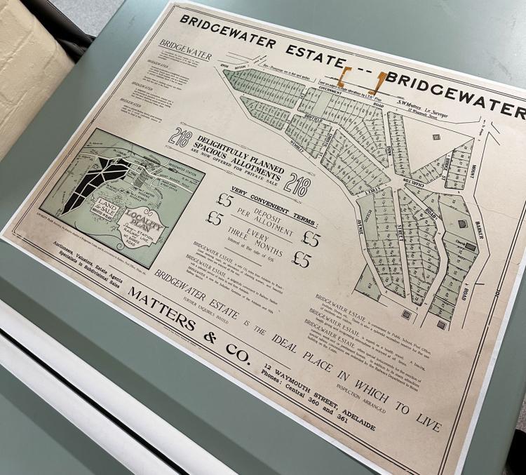
A cadastral map of Bridgewater Estate, 1924. SLSA: zgmp 830.9 bjc-c Bridgewater 1924
A cadastral map of Bridgewater Estate, part of Bridgewater, South Australia. Includes allotment numbers and dimensions, roads, landmarks, major buildings and reserves. Locality plan shows location of estate and gives location and the names of owners of some surrounding properties. The locations of the railway line, station, Bridgewater Creek, church, hotel, mill, institute and Rudd's post office and store are shown. SLSA: zgmp 830.9 bjc-c Bridgewater 1924 

Among the collection are maps that depict the evolution of urban landscapes, streets and landmarks long vanished or transformed leap back into existence, offering a visual narrative of urban development and societal change. The preservation of these maps is also a testament to the community's commitment to its heritage. It underscores the importance of safeguarding cultural artifacts for future generations, ensuring that the stories embedded within these maps continue to inspire and inform.  

The craftsmanship that went into these designs is astounding. Back in the day, making a map wasn’t just about some lines on paper. It took real skill, patience, and maybe a touch of artistic flair to bring these landscapes to life. Each swirl of ink, each tiny label, it’s like a work of art, a testament to the dedication of those cartographers who saw the world through their quill-tipped pens. One of the beachside maps even has the instruction  

“Sand is money, sand is in great demand, plenty of material to build one’s own home, no cost for material, no skilled labor required.”  

This is accompanied by the most beautiful hand-drawn pictures you can imagine.  

As they find their place within the library's collection, they will continue to inspire curiosity, spark imagination, and foster a deeper appreciation for the rich tapestry of our collective history. These maps are more than just paper and ink. They’re lessons waiting to be learned, adventures waiting to be had, stories waiting to be told. 

If you’re interested in finding out more about your suburb or town, see our Research Guide on South Australian places: Researching a town or suburb 

Written by Rachel Small, Published Collections Librarian